
Welcome to The Digital Route 66. We are an archive for all media focusing on historic US Route 66. We are serving as a media preservation warehouse. If you have historic Route 66 pictures, video, audio recordings, or printed media we would like to warehouse it for preservation for future generations. If you have content to contribute please contact Rick Marshall at digitalroute66@gmail.com
Monday, November 14, 2011
Update to Route 66 Community Map
Made an update to the Route 66 Community Map located on our "Community Map" Tab and here: Link. This new map includes links to photos for the Illinois Route 66 Places. I will be working on the Missouri Route 66 Places next. Please send me your favorite places if you want to see them included on the Route 66 Community Map.
Sunday, October 23, 2011
New Route 66 Community Map Added to ArcGIS Online
We finished digitizing the primary Route 66 highway from Chicago, Illinois to Santa Monica, California on ArcGIS Online. You can see the map on ArcGIS Online at: http://bit.ly/ouLaKV or view it from the applet below.
The entire route is digitized along with selected roadside attractions along the route in Illinois. We would like to solicit your favorite content (places, pictures, postcards, etc) from places along the route. If you have content you would like to see added to the map please let us know at rick.marshall@verticalgeo.com You can follow the progress on the Route 66 Community Map here on the Digital Route 66 Blog View Larger Map
The entire route is digitized along with selected roadside attractions along the route in Illinois. We would like to solicit your favorite content (places, pictures, postcards, etc) from places along the route. If you have content you would like to see added to the map please let us know at rick.marshall@verticalgeo.com You can follow the progress on the Route 66 Community Map here on the Digital Route 66 Blog View Larger Map
Sunday, October 16, 2011
Route 66 Corridor Preservation Program Grant Awards – 2011
It is good to see several of the roadside icons get matching funding grants for preservation. Here is a link to the announcement for the Route 66 Corridor Preservation Program Grant Awards – 2011. They are all worthy recipients! Several places will receive matching awards here locally in Illinois and Missouri.
Luna Cafe Sign Re-Lighting Ceremony
We have a Great Route 66 event next weekend in Mitchell, Illinois (about 20 minutes from downtown St Louis, Missouri). It is good to see the old neon signs along Route 66 be re-lit one at at time. I saw the announcement that matching funds had been awarded to help re-light the Luna Cafe sign and I look forward to seeing the sign in all its brilliance.
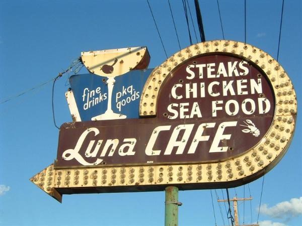
The Illinois Route 66 Association provided the following announcement on their webiste regarding the re-lighting ceremony for the Luna Cafe sign in Mitchell, Illinois (a suburb of St Louis in the St Louis Metro East):
Please join your fellow roadies on Saturday evening October 22, 2011 for the special relighting event of the classic neon sign at the historic Luna Cafe in Mitchell, Illinois. Please find attached for your reference and review the official announcement that I sent to various media sources. For those of you that may not be exactly sure how to reach the Luna, it is located approximately 5 miles east of the Chain of Rocks Bridge on Route 66 in Mitchell, Illinois. Its actual address is 201 East Chain of Rocks Road, Mitchell, IL 62040.
If accessing the location off of Interstate 270, you can take Exit 6 for Illinois Route 111 North - go to first major intersection and turn left (that's west) on E. Chain of Rocks Road (old Route 66). You'll see the old Bel Air Drive-In sign on the northwest corner of that intersection. The Luna will be on your right about 1 mile or so down.
These annual relighting parties on the Missouri side have been really neat events the last three years, and its a special experience to celebrate the restoration and rebirth of these vintage neon Route 66 signs. So, grab your calendar and mark the date down now --- plan to get down to the Luna around 6:00 PM so you won't miss the actual "flip of the switch"! We anticipate a well-attended event with roadies from Missouri, Illinois, and other locales near and far.
Jim also says, "We want a big showing of Route 66 roadies for this event, as the owner of the Luna (Larry Wofford) is planning for a big party! In fact he's going to have fried chicken and beans and cole slaw ready for 200 people. And special commemorative t-shirts will be available for purchase at a reasonable price also. Should be quite the event!" Here is a Google Map of the location of the Luna Cafe:
View Larger Map
Looking forward to seeing you at the Luna!
Thursday, October 13, 2011
The Route 66 Community Map
VerticalGeo has started a Route 66 Collaborative Map on ArcGIS Online. Please help us by contributing your content to the Route 66 map. So far we have only completed the Illinois portion of Route 66, but we will be adding more segments as we complete them. You can see the contents of the map below or on the Route 66 Project Page in the VerticalGeo website. If you would like to contribute you can use ArcGIS Online to add content. The editable version of this map can be found on ArcGIS Online at: http://bit.ly/r7yW2e
View Larger Map
Subscribe to:
Posts (Atom)